
Brea Dam Park topographic map
Interactive map
Click on the map to display elevation.
About this map
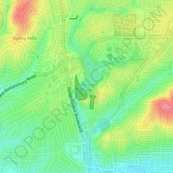
Name: Brea Dam Park topographic map, elevation, terrain.
Average elevation: 86 m
Minimum elevation: 52 m
Maximum elevation: 136 m
Other topographic maps
Click on a map to view its topography, its elevation and its terrain.
Sunny Hills
United States > California > Orange County > Fullerton
Sunny Hills, Fullerton, Orange County, CAL Fire Contract Counties, California, 92835, United States
Average elevation: 93 m
Robert E. Ward Nature Preserve
United States > California > Orange County > Fullerton > Sunny Hills
Robert E. Ward Nature Preserve, Sunny Hills, Fullerton, Orange County, CAL Fire Southern Region, California, United States
Average elevation: 105 m