Lod topographic map
Interactive map
Click on the map to display elevation.
About this map
![Lod topographic map, elevation, terrain](/pub/maps/relation/421h/cj69cz/thumbnail.jpg)
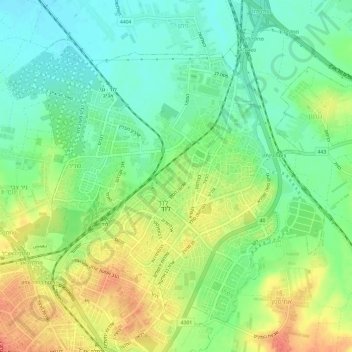
Name: Lod topographic map, elevation, terrain.
Location: Lod, Ramla Subdistrict, Center District, 7147308, Israel (31.93243 34.86123 31.97477 34.92107)
Average elevation: 59 m
Minimum elevation: 36 m
Maximum elevation: 90 m
Other topographic maps
Click on a map to view its topography, its elevation and its terrain.
![Mazkeret Batya topographic map, elevation, terrain](/pub/maps/relation/lrzs/34c518/icon.jpg)
Mazkeret Batya
Mazkeret Batya, Rehovot Subdistrict, Center District, 7680400, Israel
Average elevation: 64 m