
Thank you for supporting this site ❤️
Make a donation
Make a donation
Bat Cave topographic map
Click on the map to display elevation.
Thank you for supporting this site ❤️
Make a donation
Make a donation
About this map
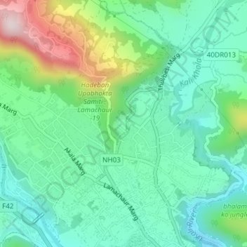
Name: Bat Cave topographic map, elevation, terrain.
Location: Bat Cave, Pokhara-19, Pokhara, Kaski, Gandaki Province, Nepal (28.26723 83.97490 28.26832 83.97602)
Average elevation: 1,021 m
Minimum elevation: 890 m
Maximum elevation: 1,354 m
Thank you for supporting this site ❤️
Make a donation
Make a donation
Other topographic maps
Click on a map to view its topography, its elevation and its terrain.
Sarangkot
Nepal > Gandaki Province > Kaski > Pokhara
The Ward is located on Sarangkot, a hill on the western side of Pokhara with an altitude of 1600m. Sarangkot is known for its panoramic Himalayan views of Dhaulagiri, Annapurna and Manaslu. It also provides an expansive view of the city of Pokhara, from the extreme north to the south including Phewa Lake.…
Average elevation: 1,139 m
Thank you for supporting this site ❤️
Make a donation
Make a donation