
Annappes topographic map
Interactive map
Click on the map to display elevation.
About this map
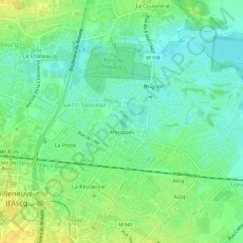
Name: Annappes topographic map, elevation, terrain.
Average elevation: 31 m
Minimum elevation: 20 m
Maximum elevation: 44 m
Other topographic maps
Click on a map to view its topography, its elevation and its terrain.
Flers-Bourg
France > Hauts-de-France > Villeneuve-d'Ascq
Flers-Bourg, Villeneuve-d'Ascq, Lille, Nord, Hauts-de-France, France métropolitaine, France
Average elevation: 34 m
Sart-Babylone
France > Hauts-de-France > Villeneuve-d'Ascq
Sart-Babylone, Villeneuve-d'Ascq, Lille, Nord, Hauts-de-France, France métropolitaine, France
Average elevation: 30 m
Prés
France > Hauts-de-France > Villeneuve-d'Ascq
Prés, Villeneuve-d'Ascq, Lille, Nord, Hauts-de-France, France métropolitaine, France
Average elevation: 33 m
Cousinerie
France > Hauts-de-France > Villeneuve-d'Ascq
Cousinerie, Villeneuve-d'Ascq, Lille, Nord, Hauts-de-France, France métropolitaine, 59650, France
Average elevation: 28 m