Geolocate

雪乡 topographic map

Interactive map

Click on the map to display elevation.

About this map

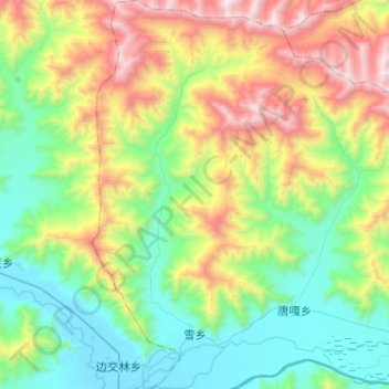
Name: 雪乡 topographic map, elevation, terrain.

Location: 雪乡, 达孜区 སྟག་རྩེ་ཆུས།, Lhassa, Tibet, Chine (29.79456 91.41831 30.01775 91.55377)

Average elevation: 4,260 m

Minimum elevation: 3,726 m

Maximum elevation: 5,373 m

Other topographic maps

Click on a map to view its topography, its elevation and its terrain.

柳梧街道

Chine > Tibet > Lhassa

柳梧街道, 堆龙德庆区 སྟོད་ལུང་བདེ་ཆེན་ཆུས།, Lhassa, Tibet, Chine

Average elevation: 4,083 m

德庆镇

Chine > Tibet > Lhassa

德庆镇, 达孜区, Lhassa, Tibet, Chine

Average elevation: 4,590 m

吉崩岗街道

Chine > Tibet > Lhassa > 吉崩岗街道

吉崩岗街道, ཁྲིན་ཀོན་ཆུས་ 城关区, Lhassa, Tibet, Chine

Average elevation: 3,656 m

Lhassa

Chine > Tibet > Lhassa

Lhassa, ཁྲིན་ཀོན་ཆུས་ / 城关区 / Chengguan, ལྷ་ས་གྲོང་ཁྱེར་ / 拉萨市 / Lhasa, Tibet, 850000, Chine

Average elevation: 4,380 m