
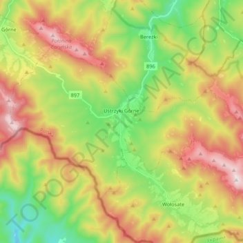
Ustrzyki Górne topographic map
Interactive map
Click on the map to display elevation.
About this map
Name: Ustrzyki Górne topographic map, elevation, terrain.
Average elevation: 849 m
Minimum elevation: 468 m
Maximum elevation: 1,339 m
Other topographic maps
Click on a map to view its topography, its elevation and its terrain.
Bieszczady
Poland > Subcarpathian Voivodeship > Bieszczady County > Zatwarnica
Bieszczady, Zatwarnica, gmina Lutowiska, Bieszczady County, Subcarpathian Voivodeship, Poland
Average elevation: 928 m
Chrewt
Poland > Subcarpathian Voivodeship > Bieszczady County > Chrewt
Chrewt, gmina Czarna, Bieszczady County, Subcarpathian Voivodeship, Poland
Average elevation: 465 m
Lutowiska
Poland > Subcarpathian Voivodeship > Bieszczady County
Lutowiska, gmina Lutowiska, Bieszczady County, Subcarpathian Voivodeship, Poland
Average elevation: 649 m