
Bridgend topographic map
Interactive map
Click on the map to display elevation.
About this map
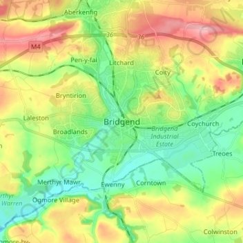
Name: Bridgend topographic map, elevation, terrain.
Average elevation: 58 m
Minimum elevation: 0 m
Maximum elevation: 145 m
Other topographic maps
Click on a map to view its topography, its elevation and its terrain.
Nant-y-moel
Vereinigtes Königreich > Wales > Bridgend County Borough
Nant-y-moel, Bridgend County Borough, Wales, CF32 7PD, Vereinigtes Königreich
Average elevation: 386 m