
East Frisian Islands topographic map
Interactive map
Click on the map to display elevation.
About this map
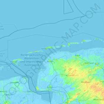
Name: East Frisian Islands topographic map, elevation, terrain.
Location: East Frisian Islands, Landkreis Aurich, Lower Saxony, Germany (53.55501 6.64404 53.79456 8.17963)
Average elevation: 1 m
Minimum elevation: -5 m
Maximum elevation: 18 m
Other topographic maps
Click on a map to view its topography, its elevation and its terrain.
Norden
Germany > Lower Saxony > Landkreis Aurich
Norden, Landkreis Aurich, Lower Saxony, 26506, Germany
Average elevation: 1 m
Ihlow
Germany > Lower Saxony > Landkreis Aurich > Ihlow
Ihlow, Landkreis Aurich, Lower Saxony, 26632, Germany
Average elevation: 1 m