
Make a donation
Udumbanchola topographic map
Click on the map to display elevation.
Make a donation
About this map
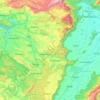
Name: Udumbanchola topographic map, elevation, terrain.
Location: Udumbanchola, Idukki, Kerala, India (9.63722 77.04139 10.08324 77.27289)
Average elevation: 833 m
Minimum elevation: 244 m
Maximum elevation: 2,438 m
Make a donation
Other topographic maps
Click on a map to view its topography, its elevation and its terrain.
Elappara
Elappara is a village in Idukki district in the Indian state of Kerala. It is one of the panchayaths in Peerumedu taluk. The area is marked by a cool climate as the region is situated at an elevation of more than 1,000 m (3,300 ft) above the sea level. Elappara is famous for its vast tea plantations.
Average elevation: 1,049 m
Adimali
Adimaly generally has a cool climate throughout the year, typical of the higher altitudes, though not as cold as Munnar. Temperatures rarely exceed 26 degrees and never drop below 10 degrees as it usually stays around 17-24 degrees. Though December–January are comparatively cooler than other months. Adimaly…
Average elevation: 786 m
Make a donation