
Selma Ben Ziada topographic map
Interactive map
Click on the map to display elevation.
About this map
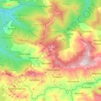
Name: Selma Ben Ziada topographic map, elevation, terrain.
Location: Selma Ben Ziada, Daïra El Aouana, Jijel, Algérie (36.59003 5.55364 36.70965 5.71079)
Average elevation: 709 m
Minimum elevation: 52 m
Maximum elevation: 1,522 m
Other topographic maps
Click on a map to view its topography, its elevation and its terrain.
El Aouana
Algérie > Jijel > Daïra El Aouana
El Aouana, Daïra El Aouana, Jijel, 18005, Algérie
Average elevation: 263 m