
驮卢镇 topographic map
Interactive map
Click on the map to display elevation.
About this map
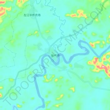
Name: 驮卢镇 topographic map, elevation, terrain.
Location: 驮卢镇, 江州区, 崇左市, 广西壮族自治区, 中国 (22.61941 107.59932 22.69941 107.67932)
Average elevation: 115 m
Minimum elevation: 78 m
Maximum elevation: 317 m
Other topographic maps
Click on a map to view its topography, its elevation and its terrain.