
Thank you for supporting this site ❤️
Make a donation
Make a donation
Khao Yai topographic map
Click on the map to display elevation.
Thank you for supporting this site ❤️
Make a donation
Make a donation
About this map
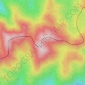
Name: Khao Yai topographic map, elevation, terrain.
Location: Khao Yai, Prachuap Khiri Khan Province, Thailand (11.48005 99.43099 11.48015 99.43109)
Average elevation: 709 m
Minimum elevation: 482 m
Maximum elevation: 858 m
Thank you for supporting this site ❤️
Make a donation
Make a donation
Other topographic maps
Click on a map to view its topography, its elevation and its terrain.
Prachuap Khiri Khan Province
Thailand > Prachuap Khiri Khan Province
Prachuap Khiri Khan covers an area totaling 6,367 square kilometers (2,458 sq mi). The province is on the Kra Isthmus, the narrow land bridge connecting the Malay Peninsula with mainland Asia. The province has the narrowest part of Thailand, just 12.38 km (7.69 mi) from the Gulf of Thailand to the border with…
Average elevation: 105 m