
Thank you for supporting this site ❤️
Make a donation
Make a donation
Pontedera topographic map
Click on the map to display elevation.
Thank you for supporting this site ❤️
Make a donation
Make a donation
About this map
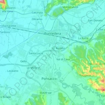
Name: Pontedera topographic map, elevation, terrain.
Location: Pontedera, Pisa, Tuscany, 56025, Italy (43.61011 10.57014 43.68059 10.70710)
Average elevation: 26 m
Minimum elevation: 2 m
Maximum elevation: 218 m
Thank you for supporting this site ❤️
Make a donation
Make a donation
Other topographic maps
Click on a map to view its topography, its elevation and its terrain.
Thank you for supporting this site ❤️
Make a donation
Make a donation
Thank you for supporting this site ❤️
Make a donation
Make a donation
Thank you for supporting this site ❤️
Make a donation
Make a donation