
Make a donation
Surxondaryo Region topographic map
Click on the map to display elevation.
Make a donation
Surxondaryo Region
The climate is continental, with mild wet winters and hot dry summers. The southern part of the region is in the Badkhiz-Karabil semi-desert ecoregion (PA0808), characterized by a savanna of pistachio and desert sedge. The northern portion is characterized by open woodlands (Gissaro-Alai open woodlands ecoregion, PA1306), with characteristic plants being pistachio, almond, walnut, apple, and juniper. Sagebrush is common at lower elevations
Make a donation
About this map
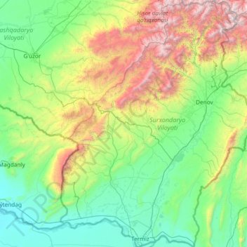
Name: Surxondaryo Region topographic map, elevation, terrain.
Location: Surxondaryo Region, Uzbekistan (37.18160 66.52157 39.03513 68.40534)
Average elevation: 1,047 m
Minimum elevation: 258 m
Maximum elevation: 4,541 m
Make a donation
Other topographic maps
Click on a map to view its topography, its elevation and its terrain.
Make a donation
Great Fergana Canal
Uzbekistan > Andijan Region > Oltinko'l District > Mirabad
Average elevation: 455 m
Make a donation
Make a donation
Make a donation
Make a donation
Make a donation
Make a donation
Make a donation
Make a donation
Make a donation
Make a donation
Make a donation
Make a donation
Make a donation
Make a donation
Shahimardan
Uzbekistan > Fergana Region > Fergana District
Shakhimardan City Resort is situated at 1975m above sea level, 155 km from Ferghana, in the picturesque mountainous district. The Kuliqurbon or Blue Lake is seven kilometers southeast of Shakhimardan. It was formed in 1766 after a series of extreme earthquakes. The lake is located at an altitude of 1,724…
Average elevation: 1,609 m
Make a donation