
Thank you for supporting this site ❤️
Make a donation
Make a donation
North Kingstown topographic map
Click on the map to display elevation.
Thank you for supporting this site ❤️
Make a donation
Make a donation
About this map
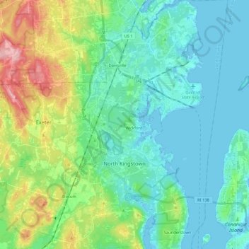
Name: North Kingstown topographic map, elevation, terrain.
Location: North Kingstown, South County, Rhode Island, United States (41.49719 -71.52280 41.65453 -71.40206)
Average elevation: 35 m
Minimum elevation: -7 m
Maximum elevation: 145 m
Thank you for supporting this site ❤️
Make a donation
Make a donation
Other topographic maps
Click on a map to view its topography, its elevation and its terrain.
West Kingston
United States > Rhode Island > South County > South Kingstown > West Kingston
Average elevation: 41 m