
Thank you for supporting this site ❤️
Make a donation
Make a donation
Newark topographic map
Click on the map to display elevation.
Thank you for supporting this site ❤️
Make a donation
Make a donation
About this map
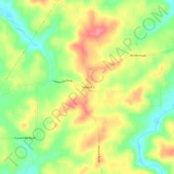
Name: Newark topographic map, elevation, terrain.
Location: Newark, Greene County, Indiana, United States (39.10893 -86.82723 39.14893 -86.78723)
Average elevation: 216 m
Minimum elevation: 173 m
Maximum elevation: 260 m
Thank you for supporting this site ❤️
Make a donation
Make a donation
Other topographic maps
Click on a map to view its topography, its elevation and its terrain.