
Thank you for supporting this site ❤️
Make a donation
Make a donation
KG Meidling topographic map
Click on the map to display elevation.
Thank you for supporting this site ❤️
Make a donation
Make a donation
About this map
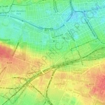
Name: KG Meidling topographic map, elevation, terrain.
Location: KG Meidling, Майдлинг, Вена, 1120, Австрия (48.16990 16.31212 48.18582 16.34973)
Average elevation: 208 m
Minimum elevation: 179 m
Maximum elevation: 241 m
Thank you for supporting this site ❤️
Make a donation
Make a donation
Other topographic maps
Click on a map to view its topography, its elevation and its terrain.
Kahlenberg
Каленберг (нем. Kahlenberg — Лысая гора) — гора в Австрии, в районе Дёблинг Вены, северо-восточная часть хребта Венский Лес, ветви нижне-австрийских Альп. Высота 484 метра над…
Average elevation: 329 m