
Thank you for supporting this site ❤️
Make a donation
Make a donation
Landore topographic map
Click on the map to display elevation.
Thank you for supporting this site ❤️
Make a donation
Make a donation
About this map
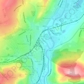
Name: Landore topographic map, elevation, terrain.
Location: Landore, Swansea, Wales, United Kingdom (51.62498 -3.94540 51.65621 -3.92934)
Average elevation: 69 m
Minimum elevation: -4 m
Maximum elevation: 191 m
Thank you for supporting this site ❤️
Make a donation
Make a donation
Other topographic maps
Click on a map to view its topography, its elevation and its terrain.