
Make a donation
Vienna topographic map
Click on the map to display elevation.
Make a donation
Vienna
Vienna is located in northeastern Austria, at the easternmost extension of the Alps in the Vienna Basin. The earliest settlement, at the location of today's inner city, was south of the meandering Danube while the city now spans both sides of the river. Elevation ranges from 151 to 542 m (495 to 1,778 ft). The city has a total area of 414.65 square kilometers (160.1 sq mi), making it the largest city in Austria by area.
Make a donation
About this map
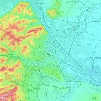
Name: Vienna topographic map, elevation, terrain.
Location: Vienna, Austria (48.11791 16.18183 48.32267 16.57751)
Average elevation: 227 m
Minimum elevation: 146 m
Maximum elevation: 631 m
Make a donation
Other topographic maps
Click on a map to view its topography, its elevation and its terrain.
Make a donation
Sportgastein
Austria > Salzburg > Bezirk St. Johann im Pongau > Bad Gastein > Naßfeld
Average elevation: 1,856 m