
Make a donation
Kope Palian topographic map
Click on the map to display elevation.
Make a donation
About this map
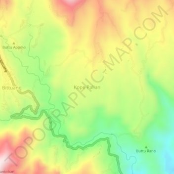
Name: Kope Palian topographic map, elevation, terrain.
Average elevation: 1,281 m
Minimum elevation: 1,021 m
Maximum elevation: 1,564 m
Make a donation
Other topographic maps
Click on a map to view its topography, its elevation and its terrain.
Make a donation
Make a donation
Make a donation
Tana Toraja Regency
Tana Toraja is centrally placed in the island of Sulawesi, 300 km north of Makassar, the provincial capital of South Sulawesi. It lies between latitude of 2°-3° South and longitude 119°-120° East (center: 3°S 120°E / 3°S 120°E / -3; 120). The total area (since the separation of the new regency…
Average elevation: 1,316 m
Make a donation
Make a donation
Make a donation
Make a donation
Make a donation
Make a donation
Make a donation
Make a donation
Somba Opu
The total area is 28.09 km2 or 2,809 Ha (1.49% of the total area of Gowa Regency) with an altitude of 25 metres above sea level. Most of the area is located in the lowlands with geographic coordinates at 5°12'5"S 119°27'15"E. The natural border with the neighbouring district of Pallangga is the Jeneberang…
Average elevation: 10 m
Make a donation
Make a donation
Make a donation
Make a donation
Make a donation
Make a donation
Make a donation
Make a donation
Jeneponto
Jeneponto Regency (Makasar: ᨍᨙᨊᨙᨄᨚᨈᨚ, romanized: Je’ne’ponto, Makasar pronunciation: [ɟʝeʔ.nep.ˈpʰɔn.t̪ʰɔ]) is a regency of South Sulawesi Province of Indonesia. It covers most of the south coast of the southern peninsula of Sulawesi, with a total area of 796.00 km2 and a…
Average elevation: 145 m
Make a donation
Make a donation
Make a donation
Make a donation
Make a donation
Make a donation