
Hoon Hay topographic map
Interactive map
Click on the map to display elevation.
About this map
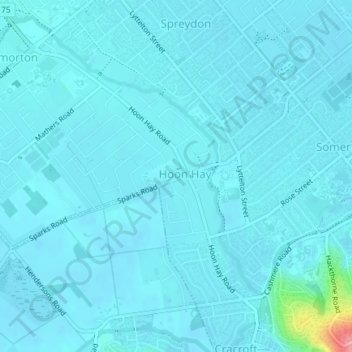
Name: Hoon Hay topographic map, elevation, terrain.
Average elevation: 16 m
Minimum elevation: 8 m
Maximum elevation: 110 m
Other topographic maps
Click on a map to view its topography, its elevation and its terrain.
New Brighton
New Zealand > Canterbury > Christchurch
New Brighton, Christchurch, Canterbury, New Zealand
Average elevation: 3 m
Papanui
New Zealand > Canterbury > Christchurch
Papanui, Frank Street, Papanui, Christchurch, Christchurch City, Canterbury, 8052, New Zealand
Average elevation: 14 m
Godley Head
New Zealand > Canterbury > Christchurch
Godley Head, Linwood-Central-Heathcote Community, Christchurch, Christchurch City, Canterbury, New Zealand
Average elevation: 25 m
Halswell River
New Zealand > Canterbury > Christchurch
Halswell River, Christchurch, Selwyn District, Canterbury, 7674, New Zealand
Average elevation: 15 m
Te Oranga Waikura
New Zealand > Canterbury > Christchurch
Te Oranga Waikura, Woolston, Christchurch, Christchurch City, Canterbury, New Zealand
Average elevation: 5 m
Papanui Stream
New Zealand > Canterbury > Christchurch
Papanui Stream, Christchurch, Christchurch City, Canterbury, 8052, New Zealand
Average elevation: 12 m
Kumara Reserve
New Zealand > Canterbury > Christchurch
Kumara Reserve, Hei Hei, Christchurch, Christchurch City, Canterbury, New Zealand
Average elevation: 34 m