
Thank you for supporting this site ❤️
Make a donation
Make a donation
Hartshorn topographic map
Click on the map to display elevation.
Thank you for supporting this site ❤️
Make a donation
Make a donation
About this map
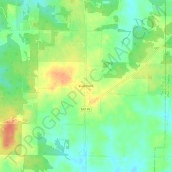
Name: Hartshorn topographic map, elevation, terrain.
Location: Hartshorn, Texas County, Missouri, 65479, United States (37.24477 -91.69042 37.28477 -91.65042)
Average elevation: 384 m
Minimum elevation: 363 m
Maximum elevation: 412 m
Thank you for supporting this site ❤️
Make a donation
Make a donation
Other topographic maps
Click on a map to view its topography, its elevation and its terrain.