
Thank you for supporting this site ❤️
Make a donation
Make a donation
Dorr topographic map
Click on the map to display elevation.
Thank you for supporting this site ❤️
Make a donation
Make a donation
About this map
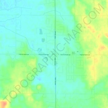
Name: Dorr topographic map, elevation, terrain.
Average elevation: 219 m
Minimum elevation: 205 m
Maximum elevation: 246 m
Thank you for supporting this site ❤️
Make a donation
Make a donation
Other topographic maps
Click on a map to view its topography, its elevation and its terrain.
Thank you for supporting this site ❤️
Make a donation
Make a donation
Trowbridge Township
United States > Michigan > Allegan County
Merson is an unincorporated community in the township at the junction of M-40 and 102 Avenue (42°26′05″N 85°51′58″W / 42.43472°N 85.86611°W / 42.43472; -85.86611 Elevation: 761 ft./232 m.).
Average elevation: 225 m
Thank you for supporting this site ❤️
Make a donation
Make a donation
Thank you for supporting this site ❤️
Make a donation
Make a donation
Thank you for supporting this site ❤️
Make a donation
Make a donation
Thank you for supporting this site ❤️
Make a donation
Make a donation