
Caen topographic map
Interactive map
Click on the map to display elevation.
About this map
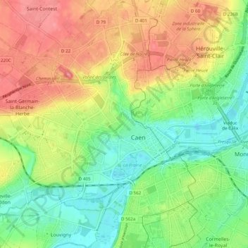
Name: Caen topographic map, elevation, terrain.
Location: Caen, Calvados, Normandy, Metropolitan France, 14000, France (49.15301 -0.41378 49.21627 -0.33073)
Average elevation: 37 m
Minimum elevation: -1 m
Maximum elevation: 81 m
Other topographic maps
Click on a map to view its topography, its elevation and its terrain.
Omaha Beach
France > Normandy > Calvados > Vierville-sur-Mer
Omaha Beach, Hamel au Prêtre, Vierville-sur-Mer, Bayeux, Calvados, Normandy, Metropolitan France, 14710, France
Average elevation: 21 m
Cour Philippin
France > Normandy > Calvados > Livarot-Pays-d'Auge
Cour Philippin, Auquainville, Livarot-Pays-d'Auge, Lisieux, Calvados, Normandy, Metropolitan France, 14140, France
Average elevation: 136 m