
Make a donation
Legau topographic map
Click on the map to display elevation.
Make a donation
About this map
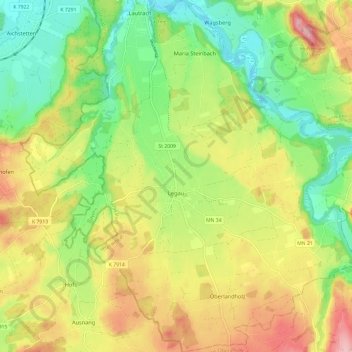
Name: Legau topographic map, elevation, terrain.
Average elevation: 674 m
Minimum elevation: 605 m
Maximum elevation: 761 m
Make a donation
Other topographic maps
Click on a map to view its topography, its elevation and its terrain.
Bollenmühle
Deutschland > Bayern > Landkreis Unterallgäu > Ottobeuren > Ollarzried
Average elevation: 767 m
Herbisried
Deutschland > Bayern > Landkreis Unterallgäu > Bad Grönenbach
Herbisried liegt in Oberschwaben in der Donau-Iller-Region, etwa drei Kilometer südlich von Bad Grönenbach, auf einer Höhe von 769 m ü. NN. An Herbisried grenzen im Uhrzeigersinn, im Norden beginnend, der Markt Bad Grönenbach, die Weiler Kornhofen, Hueb, Gmeinschwenden, Sommersberg und Greit. Mit Ausnahme…
Average elevation: 731 m
Make a donation
Make a donation
Guggenberg
Deutschland > Bayern > Landkreis Unterallgäu > Ottobeuren
Ottobeuren | Bäuerle | Betzisried | Bibelsberg | Böglins | Boschach | Brüchlins | Bühl | Daßberg | Dennenberg | Eggisried | Eheim | Eheimer Mühle | Eldern | Fröhlins | Geislins | Guggenberg | Gumpratsried | Gut | Hahnenbühl | Haitzen | Halbersberg | Hessen | Höhe | Hofs | Kloster Wald | Langenberg |…
Average elevation: 696 m
Make a donation
Halbersberg
Deutschland > Bayern > Landkreis Unterallgäu > Ottobeuren > Langenberg
Ottobeuren | Bäuerle | Betzisried | Bibelsberg | Böglins | Boschach | Brüchlins | Bühl | Daßberg | Dennenberg | Eggisried | Eheim | Eheimer Mühle | Eldern | Fröhlins | Geislins | Guggenberg | Gumpratsried | Gut | Hahnenbühl | Haitzen | Halbersberg | Hessen | Höhe | Hofs | Kloster Wald | Langenberg |…
Average elevation: 692 m
Make a donation
Brüchlins
Deutschland > Bayern > Landkreis Unterallgäu > Ottobeuren
Ottobeuren | Bäuerle | Betzisried | Bibelsberg | Böglins | Boschach | Brüchlins | Bühl | Daßberg | Dennenberg | Eggisried | Eheim | Eheimer Mühle | Eldern | Fröhlins | Geislins | Guggenberg | Gumpratsried | Gut | Hahnenbühl | Haitzen | Halbersberg | Hessen | Höhe | Hofs | Kloster Wald | Langenberg |…
Average elevation: 677 m
Make a donation
Make a donation
Gmeinschwenden
Deutschland > Bayern > Landkreis Unterallgäu > Bad Grönenbach
Das Dorf liegt etwa drei Kilometer südlich von Bad Grönenbach auf einer Höhe von 750 m ü. NN. Die Landkreisgrenze zwischen Unterallgäu und Oberallgäu verläuft unmittelbar südlich des Dorfes. Gmeinschwenden grenzt im Norden an das Dorf Herbisried, sowie im weiteren Verlauf im Uhrzeigersinn an die Weiler…
Average elevation: 726 m
Make a donation
Make a donation
Schlingen
Deutschland > Bayern > Landkreis Unterallgäu > Bad Wörishofen
Das Pfarrdorf Schlingen liegt westlich der Wertach auf einer Höhe von 642 m ü. NHN, umfasst ein Gebiet von rund 13,37 Quadratkilometer und hatte im Dezember 2021 746 Einwohner.
Average elevation: 645 m
Make a donation
Dietratried
Deutschland > Bayern > Landkreis Unterallgäu
Das Kirchdorf Dietratried liegt drei Kilometer nordwestlich von Wolfertschwenden, auf einer Höhe von 651 m ü. NN.
Average elevation: 680 m
Make a donation
Stockheim
Deutschland > Bayern > Landkreis Unterallgäu > Bad Wörishofen > Stockheim
Average elevation: 629 m
Griesthal
Deutschland > Bayern > Landkreis Unterallgäu > Markt Rettenbach > Griesthal
Average elevation: 759 m
Make a donation
Make a donation
Make a donation