
Digah topographic map
Interactive map
Click on the map to display elevation.
About this map
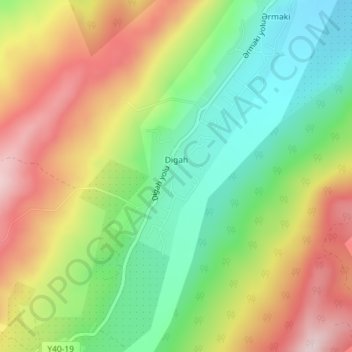
Name: Digah topographic map, elevation, terrain.
Location: Digah, Quba District, Quba - Khachmaz, Azerbaijan (41.26286 48.49137 41.27512 48.50443)
Average elevation: 876 m
Minimum elevation: 725 m
Maximum elevation: 1,060 m
Other topographic maps
Click on a map to view its topography, its elevation and its terrain.
Dağlı
Azerbaijan > Quba - Khachmaz > Guba
Dağlı, Guba, Quba District, Quba - Khachmaz, Azerbaijan
Average elevation: 642 m
Khachmaz
Khachmaz, Khachmaz District, Quba - Khachmaz, 2700, Azerbaijan
Average elevation: 50 m