Geolocate

Unaka Springs topographic map

Interactive map

Click on the map to display elevation.

About this map

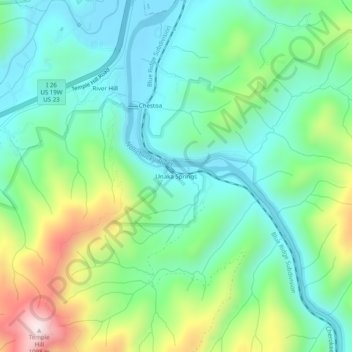
Name: Unaka Springs topographic map, elevation, terrain.

Location: Unaka Springs, Unicoi County, East Tennessee, Tennessee, 37650, United States (36.07761 -82.46153 36.11761 -82.42153)

Average elevation: 680 m

Minimum elevation: 502 m

Maximum elevation: 1,112 m

Other topographic maps

Click on a map to view its topography, its elevation and its terrain.

Flag Pond

United States > Tennessee > Unicoi County

Flag Pond, Unicoi County, East Tennessee, Tennessee, 37657, United States

Average elevation: 846 m

Erwin

United States > Tennessee > Unicoi County

Erwin, Unicoi County, Tennessee, 37650, United States

Average elevation: 599 m

Marbleton

United States > Tennessee > Unicoi County > Unicoi > Marbleton

Marbleton, Unicoi, Unicoi County, Tennessee, 37692, United States

Average elevation: 639 m

Lamar Alexander Rocky Fork State Park

United States > Tennessee > Unicoi County

Lamar Alexander Rocky Fork State Park, Unicoi County, East Tennessee, Tennessee, 37657, United States

Average elevation: 1,006 m

Pleasant Garden

United States > Tennessee > Unicoi County > Pleasant Garden

Pleasant Garden, Unicoi County, Tennessee, United States

Average elevation: 1,195 m

Unicoi

United States > Tennessee > Unicoi County

Unicoi, Unicoi County, Tennessee, United States

Average elevation: 709 m