
Make a donation
Saint Lucie County topographic map
Click on the map to display elevation.
Make a donation
About this map
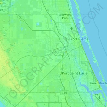
Name: Saint Lucie County topographic map, elevation, terrain.
Location: Saint Lucie County, Florida, United States (27.20558 -80.68000 27.55871 -80.13805)
Average elevation: 8 m
Minimum elevation: -3 m
Maximum elevation: 57 m
Make a donation
Other topographic maps
Click on a map to view its topography, its elevation and its terrain.
Jacksonville
United States > Florida > Duval County > Jacksonville
Just south of Jacksonville and north of Saint Augustine is the boundary of where the Floridian Peninsula ends and Continental North America begins; Jacksonville is north of that line. While still in the North American Coastal plain, the topography begins to take on slight Piedmont characteristics. Like the…
Average elevation: 9 m
Make a donation
Highland Woods Golf & Country Club
United States > Florida > Lee County > Bonita Springs
Average elevation: 5 m