
Make a donation
Phichit Province topographic map
Click on the map to display elevation.
Make a donation
About this map
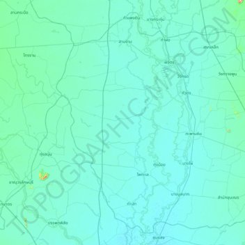
Name: Phichit Province topographic map, elevation, terrain.
Location: Phichit Province, Thailand (15.90889 99.97609 16.59867 100.77304)
Average elevation: 40 m
Minimum elevation: 25 m
Maximum elevation: 335 m
Make a donation
Other topographic maps
Click on a map to view its topography, its elevation and its terrain.
Chiang Mai
The city is situated in a valley on a river basin in the Thai highlands and is on average at 300 m (1,000 ft) elevation. Chiang Mai's city centre sits west of the Ping River, a tributary to the Chao Phraya River, while the city's sprawl extends north-west, south-west, north-east and east of the river. To the…
Average elevation: 424 m
Make a donation
Make a donation
Bangkok
Bangkok is situated in the Chao Phraya River delta in Thailand's central plain. The river meanders through the city in a southerly direction, emptying into the Gulf of Thailand approximately 25 kilometres (16 mi) south of city centre. The area is flat and low-lying, with an average elevation of 1.5 metres (4…
Average elevation: 4 m
Make a donation
Make a donation