
Thank you for supporting this site ❤️
Make a donation
Make a donation
Nauendorf topographic map
Click on the map to display elevation.
Thank you for supporting this site ❤️
Make a donation
Make a donation
About this map
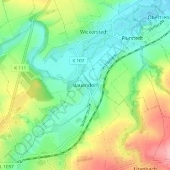
Name: Nauendorf topographic map, elevation, terrain.
Average elevation: 183 m
Minimum elevation: 138 m
Maximum elevation: 267 m
Thank you for supporting this site ❤️
Make a donation
Make a donation
Other topographic maps
Click on a map to view its topography, its elevation and its terrain.
Lohteich
Deutschland > Thüringen > Landkreis Weimarer Land > Apolda > Herressen
Average elevation: 198 m