
Bergen (NH) topographic map
Interactive map
Click on the map to display elevation.
About this map
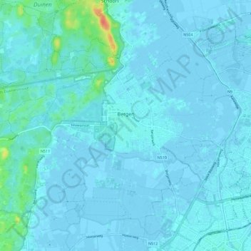
Name: Bergen (NH) topographic map, elevation, terrain.
Location: Bergen (NH), Nordholland, Niederlande (52.64018 4.64039 52.69384 4.75246)
Average elevation: 4 m
Minimum elevation: -4 m
Maximum elevation: 44 m
Other topographic maps
Click on a map to view its topography, its elevation and its terrain.
Egmond aan den Hoef
Niederlande > Nordholland > Bergen (NH)
Egmond aan den Hoef, Bergen (NH), Nordholland, Niederlande
Average elevation: 3 m