
Thank you for supporting this site ❤️
Make a donation
Make a donation
Pano Panagia topographic map
Click on the map to display elevation.
Thank you for supporting this site ❤️
Make a donation
Make a donation
Pano Panagia
Pano Panayia (Greek: Πάνω Παναγιά); also known as Panayia (Greek: Παναγιά), is a mountainous village in Cyprus, located at an altitude of 900 metres in the Paphos mountain range, on the outskirts of Paphos forest and 35 minutes from Paphos International Airport. The name Panayia is from the name of the region, Agia, and <<Pano>> that means <<up>> in Greek..
Thank you for supporting this site ❤️
Make a donation
Make a donation
About this map
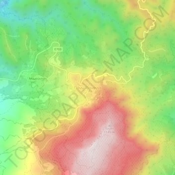
Name: Pano Panagia topographic map, elevation, terrain.
Location: Pano Panagia, Paphos District, Cyprus (34.89956 32.61150 34.93956 32.65150)
Average elevation: 771 m
Minimum elevation: 425 m
Maximum elevation: 1,143 m
Thank you for supporting this site ❤️
Make a donation
Make a donation