
Jiuzhaigou topographic map
Click on the map to display elevation.
Jiuzhaigou
The county consists of nine villages in a valley in Sichuan Province. The main ethnic group in the county is Han, with the second being Tibetan. The county seat has an altitude of about 1,400 m (4,600 ft).[1] It has a total area of 2,041 square miles (5,286 km2).[2] As of 2015, the county's total population was 67,519.[2]
About this map
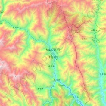
Name: Jiuzhaigou topographic map, elevation, terrain.
Average elevation: 2,520 m
Minimum elevation: 1,182 m
Maximum elevation: 4,352 m
Other topographic maps
Click on a map to view its topography, its elevation and its terrain.
Jiuzhai Valley National Park
China > Sichuan > Jiuzhaigou County
The Jiuzhaigou valley is part of the Min Mountains on the edge of the Tibetan Plateau and stretches over 72,000 hectares (180,000 acres). It is known for its many multi-level waterfalls, colorful lakes, and snow-capped peaks. Its elevation ranges from 2,000 to 4,500 metres (6,600 to 14,800 ft).
Average elevation: 3,424 m