
Thank you for supporting this site ❤️
Make a donation
Make a donation
Belesar topographic map
Click on the map to display elevation.
Thank you for supporting this site ❤️
Make a donation
Make a donation
About this map
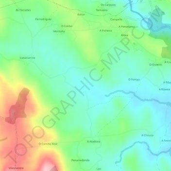
Name: Belesar topographic map, elevation, terrain.
Location: Belesar, Vilalba, Tierra Chá, Lugo, Galicia, España (43.25210 -7.79797 43.29210 -7.75797)
Average elevation: 471 m
Minimum elevation: 414 m
Maximum elevation: 593 m
Thank you for supporting this site ❤️
Make a donation
Make a donation
Other topographic maps
Click on a map to view its topography, its elevation and its terrain.