
Thank you for supporting this site ❤️
Make a donation
Make a donation
Glöbusch topographic map
Click on the map to display elevation.
Thank you for supporting this site ❤️
Make a donation
Make a donation
Glöbusch
Glöbusch ist ein Ortsteil in Unterodenthal in der Gemeinde Odenthal im Rheinisch-Bergischen Kreis. Er liegt auf der Höhe an der Bergstraße, die von Odenthal nach Burscheid führt.
Thank you for supporting this site ❤️
Make a donation
Make a donation
About this map
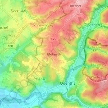
Name: Glöbusch topographic map, elevation, terrain.
Average elevation: 136 m
Minimum elevation: 66 m
Maximum elevation: 211 m
Thank you for supporting this site ❤️
Make a donation
Make a donation
Other topographic maps
Click on a map to view its topography, its elevation and its terrain.
Scherfbachtal
Deutschland > Nordrhein-Westfalen > Rheinisch-Bergischer Kreis > Odenthal > Höffe
Average elevation: 165 m
Unterbreidbach
Deutschland > Nordrhein-Westfalen > Rheinisch-Bergischer Kreis > Odenthal > Neschen > Unterbreidbach
Average elevation: 198 m