
Thank you for supporting this site ❤️
Make a donation
Make a donation
Euless topographic map
Click on the map to display elevation.
Thank you for supporting this site ❤️
Make a donation
Make a donation
About this map
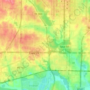
Name: Euless topographic map, elevation, terrain.
Location: Euless, Tarrant County, Texas, United States (32.81059 -97.15598 32.88163 -97.03309)
Average elevation: 167 m
Minimum elevation: 131 m
Maximum elevation: 204 m
Thank you for supporting this site ❤️
Make a donation
Make a donation
Other topographic maps
Click on a map to view its topography, its elevation and its terrain.