
Thank you for supporting this site ❤️
Make a donation
Make a donation
Kendal topographic map
Click on the map to display elevation.
Thank you for supporting this site ❤️
Make a donation
Make a donation
About this map
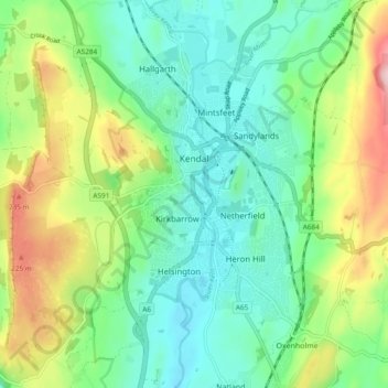
Name: Kendal topographic map, elevation, terrain.
Location: Kendal, Westmorland and Furness, England, United Kingdom (54.29620 -2.76906 54.35149 -2.70525)
Average elevation: 112 m
Minimum elevation: 32 m
Maximum elevation: 290 m
Thank you for supporting this site ❤️
Make a donation
Make a donation
Other topographic maps
Click on a map to view its topography, its elevation and its terrain.