
Villanueva del Arzobispo topographic map
Interactive map
Click on the map to display elevation.
About this map
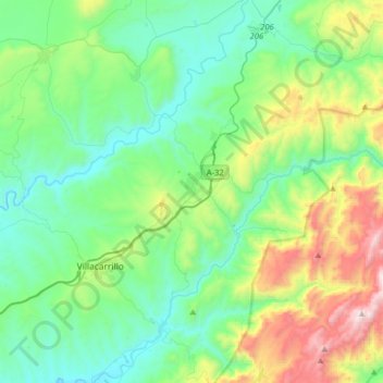
Name: Villanueva del Arzobispo topographic map, elevation, terrain.
Location: Villanueva del Arzobispo, Jaén, Andaluzia, 23330, Espanha (38.10056 -3.11487 38.22874 -2.79589)
Average elevation: 747 m
Minimum elevation: 399 m
Maximum elevation: 1,809 m
Other topographic maps
Click on a map to view its topography, its elevation and its terrain.
Parque Natural Sierras de Cazorla, Segura y las Villas
Espanha > Andaluzia > Villanueva del Arzobispo
Parque Natural Sierras de Cazorla, Segura y las Villas, A-6202, Villanueva del Arzobispo, Jaén, Andaluzia, 23330, Espanha
Average elevation: 887 m