
Grub topographic map
Interactive map
Click on the map to display elevation.
About this map
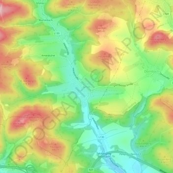
Name: Grub topographic map, elevation, terrain.
Average elevation: 410 m
Minimum elevation: 316 m
Maximum elevation: 523 m
Other topographic maps
Click on a map to view its topography, its elevation and its terrain.
Hausruck
Österreich > Niederösterreich > Bezirk Mödling > Gemeinde Wienerwald
Hausruck, Gemeinde Wienerwald, Bezirk Mödling, Niederösterreich, 2534, Österreich
Average elevation: 398 m