
Thank you for supporting this site ❤️
Make a donation
Make a donation
Old Woking topographic map
Click on the map to display elevation.
Thank you for supporting this site ❤️
Make a donation
Make a donation
About this map
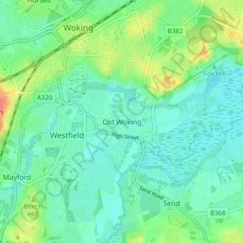
Name: Old Woking topographic map, elevation, terrain.
Location: Old Woking, Woking, Surrey, England, GU22 9HD, United Kingdom (51.28464 -0.56498 51.32464 -0.52498)
Average elevation: 31 m
Minimum elevation: 18 m
Maximum elevation: 62 m
Thank you for supporting this site ❤️
Make a donation
Make a donation
Other topographic maps
Click on a map to view its topography, its elevation and its terrain.
Horsell Common
United Kingdom > England > Surrey > Woking > Horsell > Durnford Farm
Average elevation: 29 m