
Rhodes topographic map
Interactive map
Click on the map to display elevation.
About this map
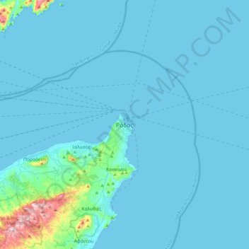
Name: Rhodes topographic map, elevation, terrain.
Average elevation: 27 m
Minimum elevation: -1 m
Maximum elevation: 473 m
Other topographic maps
Click on a map to view its topography, its elevation and its terrain.
Symi
Greece > Aegean > Rhodes Regional Unit > Emporios
Symi, Emporios, Municipality of Symi, Rhodes Regional Unit, South Aegean, Aegean, 856 00, Greece
Average elevation: 81 m
Faliraki
Greece > Aegean > Rhodes Regional Unit
Faliraki, Municipality of Rhodes, Rhodes Regional Unit, South Aegean, Aegean, 851 00, Greece
Average elevation: 26 m
Megisti
Greece > Aegean > Rhodes Regional Unit > Municipality of Meyisti
Megisti, Municipality of Meyisti, Rhodes Regional Unit, South Aegean, Aegean, 851 11, Greece
Average elevation: 40 m
Embonas
Greece > Aegean > Rhodes Regional Unit > Embonas
Embonas, Municipality of Rhodes, Rhodes Regional Unit, South Aegean, Aegean, 85108, Greece
Average elevation: 508 m