
Lauenförde topographic map
Interactive map
Click on the map to display elevation.
About this map
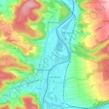
Name: Lauenförde topographic map, elevation, terrain.
Average elevation: 173 m
Minimum elevation: 88 m
Maximum elevation: 315 m
Other topographic maps
Click on a map to view its topography, its elevation and its terrain.
Holzminden (arrondissement)
Allemagne > Basse-Saxe > Holzminden (arrondissement)
Holzminden (arrondissement), Basse-Saxe, Allemagne
Average elevation: 237 m
Delligsen
Allemagne > Basse-Saxe > Holzminden (arrondissement)
Delligsen, Holzminden (arrondissement), Basse-Saxe, Allemagne
Average elevation: 222 m