
Rees topographic map
Interactive map
Click on the map to display elevation.
About this map
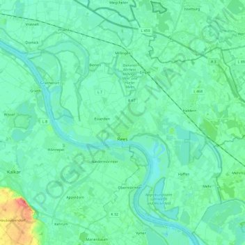
Name: Rees topographic map, elevation, terrain.
Location: Rees, Kreis Kleve, Rhénanie-du-Nord-Westphalie, Allemagne (51.70207 6.30239 51.83333 6.53419)
Average elevation: 18 m
Minimum elevation: 7 m
Maximum elevation: 71 m
Other topographic maps
Click on a map to view its topography, its elevation and its terrain.
Am Lobsteg
Allemagne > Rhénanie-du-Nord-Westphalie > Kreis Kleve > Rheurdt
Am Lobsteg, Rheurdt, Kreis Kleve, Rhénanie-du-Nord-Westphalie, 47509, Allemagne
Average elevation: 41 m
Issum
Allemagne > Rhénanie-du-Nord-Westphalie > Kreis Kleve
Issum, Kreis Kleve, Rhénanie-du-Nord-Westphalie, 47661, Allemagne
Average elevation: 31 m