
Thank you for supporting this site ❤️
Make a donation
Make a donation
Readsboro topographic map
Click on the map to display elevation.
Thank you for supporting this site ❤️
Make a donation
Make a donation
About this map
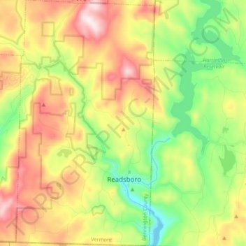
Name: Readsboro topographic map, elevation, terrain.
Location: Readsboro, Bennington County, Vermont, 05350, United States (42.73919 -73.01865 42.85909 -72.92627)
Average elevation: 596 m
Minimum elevation: 334 m
Maximum elevation: 939 m
Thank you for supporting this site ❤️
Make a donation
Make a donation
Other topographic maps
Click on a map to view its topography, its elevation and its terrain.
Thank you for supporting this site ❤️
Make a donation
Make a donation
Thank you for supporting this site ❤️
Make a donation
Make a donation