Flowerdale topographic map
Interactive map
Click on the map to display elevation.
About this map
![Flowerdale topographic map, elevation, terrain](/pub/maps/relation/rf3q/wp6cnh/thumbnail.jpg)
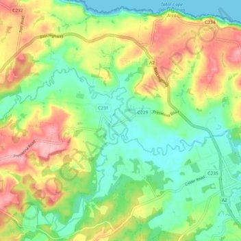
Name: Flowerdale topographic map, elevation, terrain.
Location: Flowerdale, Waratah-Wynyard, Tasmania, Australia (-40.99120 145.61526 -40.94906 145.70557)
Average elevation: 58 m
Minimum elevation: 0 m
Maximum elevation: 145 m
Other topographic maps
Click on a map to view its topography, its elevation and its terrain.
![Jackeys Marsh topographic map, elevation, terrain](/pub/maps/relation/66tp/kvx9dn/icon.jpg)
Jackeys Marsh
Jackeys Marsh, Meander Valley, Tasmania, 7304, Australia
Average elevation: 760 m
![Goulds Country topographic map, elevation, terrain](/pub/maps/relation/j7t6/k156dn/icon.jpg)
Goulds Country
Goulds Country, Break O'Day, Tasmania, 7216, Australia
Average elevation: 308 m
![Lake Belton topographic map, elevation, terrain](/pub/maps/relation/f9b3/jzvjs8/icon.jpg)
Lake Belton
Lake Belton, Derwent Valley, Tasmania, Australia
Average elevation: 1,056 m
![Vale of Belvoir Conservation Area topographic map, elevation, terrain](/pub/maps/relation/kn14/dr54nh/icon.jpg)
Vale of Belvoir Conservation Area
Vale of Belvoir Conservation Area, Kentish, Tasmania, Australia
Average elevation: 866 m
![Erith Island topographic map, elevation, terrain](/pub/maps/relation/f4nh/w2h5tp/icon.jpg)
Erith Island
Erith Island, Flinders Council, Tasmania, Australia
Average elevation: 23 m
![Chicken Island topographic map, elevation, terrain](/pub/maps/relation/k9s8/xrh1mt/icon.jpg)
Chicken Island
Chicken Island, Huon Valley, Tasmania, Australia
Average elevation: 4 m
![West Hobart topographic map, elevation, terrain](/pub/maps/relation/hdm2/clvgkl/icon.jpg)
West Hobart
West Hobart, Hobart, City of Hobart, Tasmania, 7000, Australia
Average elevation: 105 m
![Mount Nelson topographic map, elevation, terrain](/pub/maps/relation/8kdn/62x8m2/icon.jpg)
Mount Nelson
Mount Nelson, Hobart, City of Hobart, Tasmania, 7007, Australia
Average elevation: 198 m
![Lake Pedder topographic map, elevation, terrain](/pub/maps/relation/g9tf/csttj/icon.jpg)
Lake Pedder
Australia > Tasmania > Strathgordon
Lake Pedder, Strathgordon, Derwent Valley, Tasmania, Australia
Average elevation: 366 m
![Mersey Forest topographic map, elevation, terrain](/pub/maps/relation/641h/16vb57/icon.jpg)
Mersey Forest
Mersey Forest, Meander Valley, Tasmania, Australia
Average elevation: 866 m
![Launceston topographic map, elevation, terrain](/pub/maps/relation/43mt/zs8m4s/icon.jpg)
Launceston
Launceston, City of Launceston, Tasmania, Australia
Average elevation: 194 m
![Port Arthur topographic map, elevation, terrain](/pub/maps/relation/n1cz/cl133l/icon.jpg)
Port Arthur
Port Arthur, Tasman, Tasmania, 7182, Australia
Average elevation: 153 m
![Highland Waters topographic map, elevation, terrain](/pub/maps/way/s5dn/s5z5bb3/icon.jpg)
Highland Waters
Australia > Tasmania > London Lakes
Highland Waters, London Lakes, Central Highlands, Tasmania, Australia
Average elevation: 759 m
![Bullock Hill topographic map, elevation, terrain](/pub/maps/node/9zz4/fpwwr33q/icon.jpg)
Bullock Hill
Bullock Hill, Grove, Huon Valley, Tasmania, Australia
Average elevation: 147 m
![Flinders Island topographic map, elevation, terrain](/pub/maps/relation/32rr/xz3tp/icon.jpg)
Flinders Island
Flinders Island, Tasmania, 7255, Australia
Average elevation: 20 m
![Grey Mares Tail topographic map, elevation, terrain](/pub/maps/node/mh1h/5gkfhlgp/icon.jpg)
Grey Mares Tail
Australia > Tasmania > St Marys
Grey Mares Tail, St Marys, Break O'Day, Tasmania, Australia
Average elevation: 349 m
![Anderson Island topographic map, elevation, terrain](/pub/maps/relation/3pdn/pdw8nx/icon.jpg)
Anderson Island
Anderson Island, Flinders Council, Tasmania, Australia
Average elevation: 4 m
![Macquarie Island topographic map, elevation, terrain](/pub/maps/relation/24tj/lw5f9m/icon.jpg)
Macquarie Island
Macquarie Island, Huon Valley, Tasmania, Australia
Average elevation: 20 m
![Bruny Island topographic map, elevation, terrain](/pub/maps/relation/s5z4/8c57m2/icon.jpg)
Bruny Island
Australia > Tasmania > Alonnah
Bruny Island, Alonnah, Kingborough, Tasmania, Australia
Average elevation: 59 m