
Make a donation
Bel Aire topographic map
Click on the map to display elevation.
Make a donation
Bel Aire
Bel Aire is located at 37°45′50″N 97°15′58″W / 37.76389°N 97.26611°W / 37.76389; -97.26611 (37.763758, −97.266177) at an elevation of 1,394 feet (425 m). It lies on the north side of the East Fork of Chisholm Creek roughly 6 mi (9.7 km) northeast of the Arkansas River in the Wellington-McPherson Lowlands region of the Great Plains. Located on the south side of K-254 in south-central Kansas, Bel Aire is within the Wichita metropolitan area, bordered by Wichita to the south and west and bordered by Kechi to the north.
Make a donation
About this map
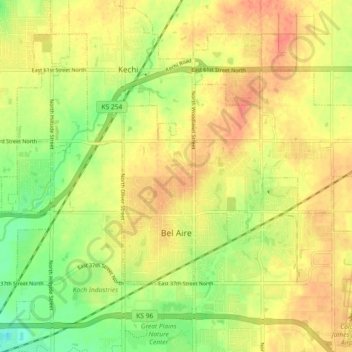
Name: Bel Aire topographic map, elevation, terrain.
Location: Bel Aire, Sedgwick County, Kansas, United States (37.75229 -97.28077 37.79596 -97.18976)
Average elevation: 424 m
Minimum elevation: 396 m
Maximum elevation: 444 m
Make a donation
Other topographic maps
Click on a map to view its topography, its elevation and its terrain.
Valley Center
United States > Kansas > Sedgwick County > Valley Center > Valley Center
Average elevation: 415 m