
Dorf topographic map
Interactive map
Click on the map to display elevation.
About this map
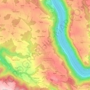
Name: Dorf topographic map, elevation, terrain.
Average elevation: 462 m
Minimum elevation: 267 m
Maximum elevation: 605 m
Other topographic maps
Click on a map to view its topography, its elevation and its terrain.
Gemersdorf
Österreich > Oberösterreich > Bezirk Eferding > Haibach ob der Donau > Gemersdorf
Gemersdorf, Haibach ob der Donau, Bezirk Eferding, Oberösterreich, 4083, Österreich
Average elevation: 488 m