
Make a donation
Collabassa topographic map
Click on the map to display elevation.
Make a donation
About this map
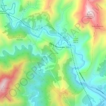
Name: Collabassa topographic map, elevation, terrain.
Location: Collabassa, Airole, Provincia di Imperia, Liguria, 18030, Italy (43.84178 7.54143 43.88178 7.58143)
Average elevation: 313 m
Minimum elevation: 34 m
Maximum elevation: 861 m
Make a donation
Other topographic maps
Click on a map to view its topography, its elevation and its terrain.
Make a donation
Make a donation
Make a donation
Make a donation
Make a donation
Bajardo
Italy > Liguria > Provincia di Imperia
Its principal settlement, Bajardo itself, is a medieval village which stands at an elevation of 900 metres (3,000 ft) on a peak at the head of the basin of the Nervia torrent.
Average elevation: 710 m
Make a donation
Make a donation
Bajardo
Italy > Liguria > Provincia di Imperia
Its principal settlement, Bajardo itself, is a medieval village which stands at an elevation of 900 metres (3,000 ft) on a peak at the head of the basin of the Nervia torrent.
Average elevation: 710 m
Make a donation