
District de Daoli topographic map
Interactive map
Click on the map to display elevation.
About this map
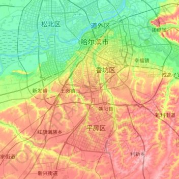
Name: District de Daoli topographic map, elevation, terrain.
Location: District de Daoli, Harbin, Heilongjiang, 150000, Chine (45.54751 126.14368 45.78716 126.62938)
Average elevation: 156 m
Minimum elevation: 112 m
Maximum elevation: 217 m
Other topographic maps
Click on a map to view its topography, its elevation and its terrain.
District d'Acheng
Chine > Heilongjiang > Harbin
District d'Acheng, Harbin, Heilongjiang, Chine
Average elevation: 244 m
Mohe
Chine > Heilongjiang > 漠河市 > 西林吉镇
Mohe, 西林吉镇, 漠河市, Préfecture de Daxing'anling, Heilongjiang, 165399, Chine
Average elevation: 537 m
黑龙江
Chine > Heilongjiang > 抚远镇
黑龙江, 抚远镇, 抚远市, 佳木斯市, Heilongjiang, 154000, Chine
Average elevation: 43 m