
Thank you for supporting this site ❤️
Make a donation
Make a donation
Adichanallur topographic map
Click on the map to display elevation.
Thank you for supporting this site ❤️
Make a donation
Make a donation
About this map
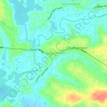
Name: Adichanallur topographic map, elevation, terrain.
Location: Adichanallur, Kollam, Kerala, 691573, India (8.84187 76.68528 8.88187 76.72528)
Average elevation: 19 m
Minimum elevation: 0 m
Maximum elevation: 68 m
Thank you for supporting this site ❤️
Make a donation
Make a donation
Other topographic maps
Click on a map to view its topography, its elevation and its terrain.
Ashtamudi Lake
India > Kerala > Kollam > Kottayathukadavu
Ashtamudi Lake (Ashtamudi Kayal), in the Kollam District of the Indian state of Kerala, is the most visited backwater and lake in the state. It possesses a unique wetland ecosystem and a large palm-shaped (also described as octopus-shaped) water body, second only in size to the Vembanad estuary ecosystem of…
Average elevation: 6 m
Thank you for supporting this site ❤️
Make a donation
Make a donation